
Northeast FIRM
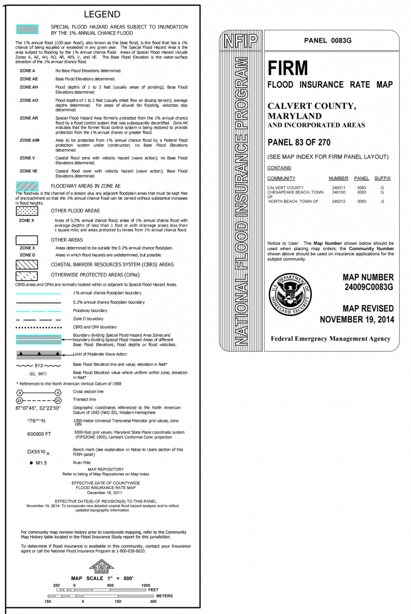
Northeast Flood Insurance Rate Map (FIRM) Map Panel 83 (extracted from FIRM Map Panel 83 of 270 Number 24009C0083G, effective November 19, 2014). Due to the size of the FIRM maps, each map has been divided into map sections (Notes to Users, the map itself, and other map components). The "Notes to Users" section was extracted from the map and offered immediately below as text to facilitate reading. Scroll down to view map.
Notes to Users:
This map is for use in administering the National Flood Insurance Program. It does not necessarily identify all areas subject to flooding, particularly from local drainage sources of small size. The community map repository should be consulted for possible updated or additional flood hazard information.
To obtain more detailed information in areas where Base Flood Elevations (BFEs) and/or floodways have been determined, users are encouraged to consult the Flood Profiles and Floodway Data and/or Summary of Stillwater Elevations tables contained within the Flood Insurance Study (FIS) report that accompanies this FIRM. Users should be aware that BFEs shown on the FIRM represent rounded whole-foot elevations. These BFEs are intended for flood insurance rating purposes only and should not be used as the sole source of flood elevation information. Accordingly, flood elevation data presented in the FIS report should be utilized in conjunction with the FIRM for purposes of construction and/or floodplain management.
Coastal Base Flood Elevations shown on this map apply only landward of 0.0' North American Vertical Datum of 1988 (NAVD 88). Users of this FIRM should be aware that coastal flood elevations are also provided in the Summary of Stillwater Elevations tables in the Flood Insurance Study report for this jurisdiction. Elevations shown in the Summary of Stillwater Elevations tables should be used for construction and/or floodplain management purposes when they are higher than the elevations shown on this FIRM.
Boundaries of the floodways were computed at cross sections and interpolated between cross sections. The floodways were based on hydraulic considerations with regard to requirements of the National Flood Insurance Program. Floodway widths and other pertinent floodway data are provided in the Flood Insurance Study report for this jurisdiction.
Certain areas not in Special Flood Hazard Areas may be protected by flood control structures. Refer to Section 2.4 "Flood Protection Measures" of the Flood Insurance Study report for information on flood control structures for this jurisdiction.
The projection used in the preparation of this map was Universal Transverse Mercator (UTM) zone 18N. The horizontal datum was NAD 83, GRS 80 spheroid. Differences in datum, spheroid, projection or UTM zones used in the production of FIRMs for adjacent jurisdictions may result in slight positional differences in map features across jurisdiction boundaries. These differences do not affect the accuracy of information shown on this FIRM.
Flood elevations on this map are referenced to the North American Vertical Datum of 1988. These flood elevations must be compared to structure and ground elevations referenced to the same vertical datum. For information regarding conversion between the National Geodetic Vertical Datum of 1929 and the North American Vertical Datum of 1988, visit the National Geodetic Survey website or contact the National Geodetic Survey at the following address:
NGS Information Services
NOAA, N/NGS12
National Geodetic Survey
SSMC-3, #9202
1315 East-West Highway
Silver Spring, Maryland 20910-3282
(301) 713-3242
To obtain current elevation, description, and/or location information for bench marks shown on this map, please contact the Information Services Branch of the National Geodetic Survey at (301) 713-3242, or visit its website.
Base map imagery was provided by the Maryland State Highway Administration on behalf of the Maryland State Imagery Acquisitions Partnership. The digital ortho imagery was compiled at a scale of 1:100 with a 6 inch ground pixel resolution, and is dated 2011.
This map reflects more detailed and up-to-date stream channel configurations than those shown on the previous FIRM for this jurisdiction. The floodplains and floodways that were transferred from the previous FIRM may have been adjusted to confirm to these new stream channel configurations. As a result, the Flood Profiles and Floodway Data tables in the Flood Insurance Study Report (which contains authoritative hydraulic data) may reflect stream channel distances that differ from what is shown on this map.
Corporate limits shown on this map are based on the best data available at the time of publication. Because changes due to annexations or de-annexations may have occurred after this map was published, map users should contact appropriate community officials to verify current corporate limit locations.
Please refer to the separately printed Map Index for an overview map of the county showing the layout of map panels; community map repository addresses; and a Listing of Communities table containing National Flood Insurance Program dates for each community as well as a listing of the panels on which each community is located.
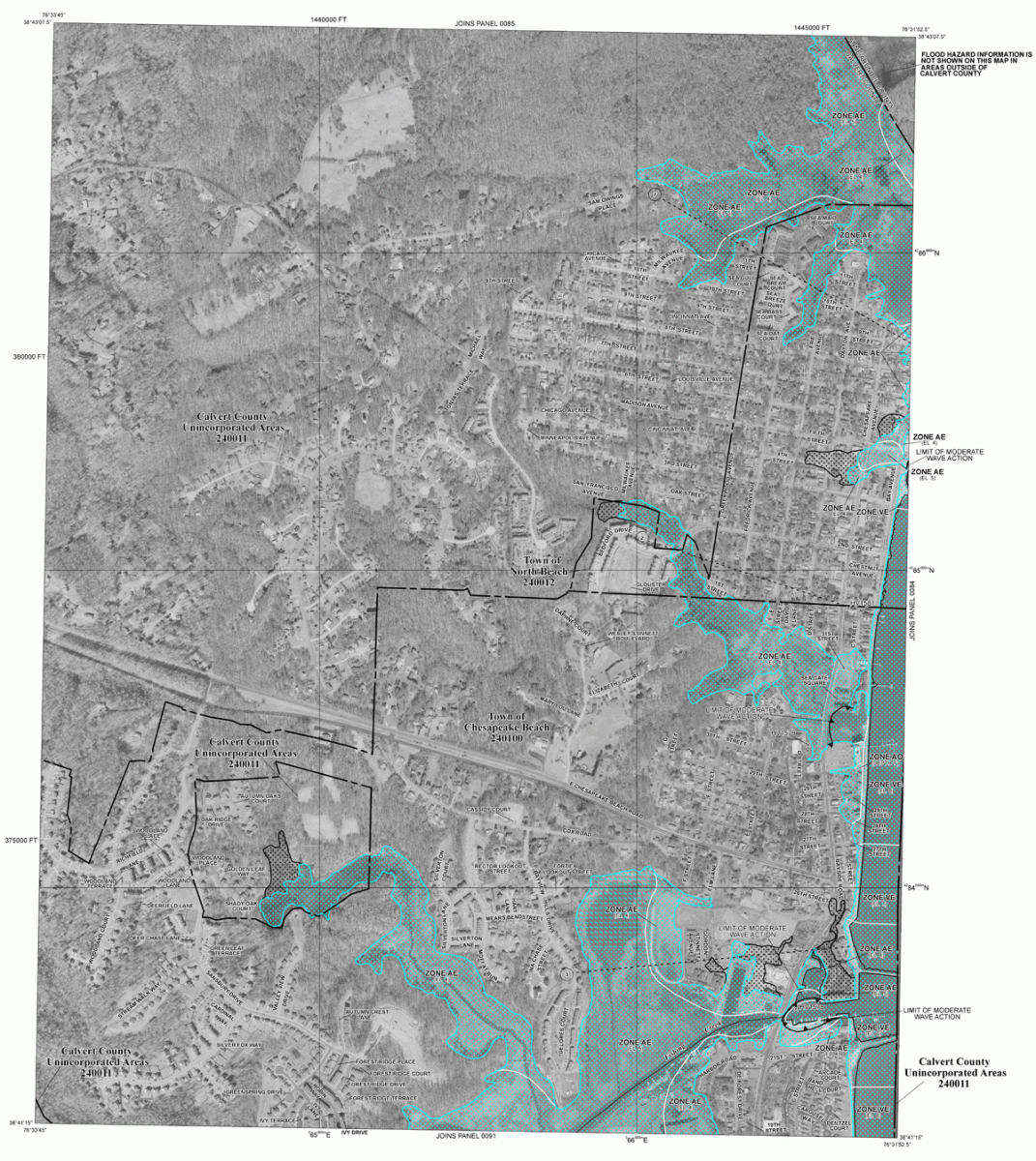
The AE Zone category has been divided by a Limit of Moderate Wave Action (LiMWA). The LiMWA represents the approximate landward limit of the 1.5-foot breaking wave. The effects of wave hazards between the VE Zone and the LiMWA (or between the shoreline and the LiMWA for areas where VE Zones are not identified) will be similar to, but less severe than those in the VE Zone.
Contact the FEMA Map Information eXchange at 1-877-336-2627 for information on available products associated with this FIRM. Available products may include previously issued Letters of Map Change, a Flood Insurance Study report, and/or digital versions of this map. The FEMA Map Information eXchange may also be reached by Fax at 1-800-358-9620 and their website.
If you have questions about this map or questions concerning the National Flood Insurance Program in general, please call 1-877-FEMA MAP (1-877-336-2627) or visit the FEMA website.