

Sandbags Available to Town Residents

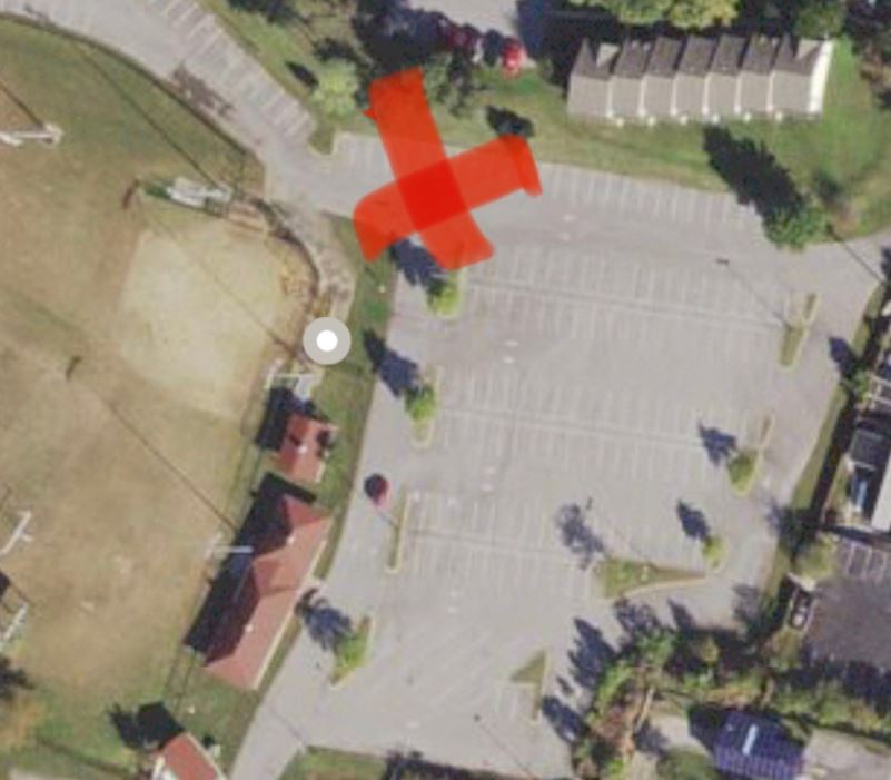
July 8, 2021 (Chesapeake Beach, MD)- Due to expected inclement weather, the Town is making sandbags available to Town residents. Sandbags are limited to (10) ten per household - please bring your own shovel. Residents can access sand at the Kellams complex parking area today. See the below image for the exact location.
For the most up to date weather outlook and advisories please click here.
Hazardous Weather Outlook National Weather Service Baltimore MD/Washington DC 510 AM EDT Thu Jul 8 2021 - Chesapeake Bay north of Pooles Island MD- Chesapeake Bay from Pooles Island to Sandy Point MD- Chesapeake Bay from Sandy Point to North Beach MD- Chesapeake Bay from North Beach to Drum Point MD- Chesapeake Bay from Drum Point MD to Smith Point VA- Tidal Potomac from Key Bridge to Indian Head MD- Tidal Potomac from Indian Head to Cobb Island MD- Tidal Potomac from Cobb Island MD to Smith Point VA- Patapsco River including Baltimore Harbor- Chester River to Queenstown MD-Eastern Bay- Choptank River to Cambridge MD and the Little Choptank River- Patuxent River to Broomes Island MD- Tangier Sound and the inland waters surrounding Bloodsworth Island-District of Columbia-Cecil-Southern Baltimore- Prince Georges-Anne Arundel-Charles-St. Marys-Calvert- Central and Southeast Montgomery-Central and Southeast Howard- Southeast Harford-Prince William/Manassas/Manassas Park-Fairfax- Arlington/Falls Church/Alexandria-Stafford-Spotsylvania- King George- 510 AM EDT Thu Jul 8 2021 This Hazardous Weather Outlook is for the Maryland portion of the Chesapeake Bay, Tidal Potomac River, and I-95 corridor through central Maryland, northern Virginia, and District of Columbia. .DAY ONE...Today and Tonight A severe storm with locally damaging wind gusts is possible this afternoon and evening, especially across the Washington and Baltimore Metropolitan areas. An isolated instance of flooding is possible as well. A Tropical Storm Warning remains in effect for St. Mary`s and Calvert counties, including the adjacent waters along the Chesapeake Bay and Lower tidal Potomac river. Most of the impact from Elsa will occur tonight. Flooding rains, minor tidal flooding, and an isolated tornado are all threats. For additional information on Tropical Storm Elsa, consult the latest forecast from the National Hurricane Center. A Flash Flood Watch is in effect from this afternoon through tonight for locations near and east of Interstate 95. .DAYS TWO THROUGH SEVEN...Friday through Wednesday A severe storm is possible Friday afternoon and evening, with damaging winds being the primary threat. There is a slight severe storm threat for Sunday and Monday. Scattered severe storms are possible. .SPOTTER INFORMATION STATEMENT... Spotter activation may be needed this afternoon and tonight. Please report any wind damage or flooding to the National Weather Service. Spotter activation may be needed for Friday as well as Sunday and Monday during the afternoon and evening hours each day. $$
Hurricane Local Statement
Tropical Storm Elsa Local Statement Advisory- Tropical Storm Elsa Local Statement Advisory Number 33 National Weather Service Baltimore MD/Washington DC AL052021 531 AM EDT Thu Jul 8 2021 This product covers Eastern West Virginia, Central and Western Maryland, Northern and Northwestern Virginia, and District of Columbia **ELSA IS EXPECTED TO IMPACT PORTIONS OF SOUTHERN MARYLAND AND ADJACENT WATERS LATE THURSDAY INTO EARLY FRIDAY**** NEW INFORMATION --------------- * CHANGES TO WATCHES AND WARNINGS: - None * CURRENT WATCHES AND WARNINGS: - A Tropical Storm Warning is in effect for Calvert and St. Marys * STORM INFORMATION: - About 450 miles south-southwest of Washington DC or about 480 miles southwest of Baltimore MD - 33.4N 81.3W - Storm Intensity 40 mph - Movement Northeast or 35 degrees at 18 mph SITUATION OVERVIEW ------------------ Tropical Storm Elsa will quickly move northeast tracking into the Carolinas today before passing through our area tonight. Elsa is expected to rapidly move off to our northeast on Friday. The main threat will be from heavy rain with 2 to 3 inches most likely and isolated totals as high as 5 inches across southern Maryland. Moderate to heavy rainfall over a few hours may cause streams and creeks to quickly rise out of their banks. An isolated tornado is possible, especially across extreme southern Maryland near the Chesapeake Bay and lower Tidal Potomac River. There is also an isolated threat for waterspouts over the waters. Tropical Storm force winds are most likely over the waters and along the immediate shoreline of eastern Calvert and southeast St Marys Counties. POTENTIAL IMPACTS ----------------- * FLOODING RAIN: Protect against dangerous rainfall flooding having possible significant impacts east of Interstate 95. Potential impacts include: - Moderate rainfall flooding may prompt several evacuations and rescues. - Rivers and tributaries may quickly become swollen with swifter currents and overspill their banks in a few places, especially in usually vulnerable spots. Small streams, creeks, canals, arroyos, and ditches overflow. - Flood waters can enter some structures or weaken foundations. Several places may experience expanded areas of rapid inundation at underpasses, low-lying spots, and poor drainage areas. Some streets and parking lots take on moving water as storm drains and retention ponds overflow. Driving conditions become hazardous. Some road and bridge closures. Elsewhere across Eastern West Virginia, Central and Western Maryland, Northern and Northwestern Virginia, and District of Columbia, little to no impact is anticipated. * WIND: Protect against hazardous wind having possible limited impacts across southern Maryland. Potential impacts in this area include: - Damage to porches, awnings, carports, sheds, and unanchored mobile homes. Unsecured lightweight objects blown about. - Many large tree limbs broken off. A few trees snapped or uprooted, but with greater numbers in places where trees are shallow rooted. Some fences and roadway signs blown over. - A few roads impassable from debris, particularly within urban or heavily wooded places. Hazardous driving conditions on bridges and other elevated roadways. - Scattered power and communications outages. Elsewhere across Eastern West Virginia, Central and Western Maryland, Northern and Northwestern Virginia, and District of Columbia, little to no impact is anticipated. * TORNADOES: Protect against a tornado event having possible limited impacts across extreme southern Maryland. Potential impacts include: - The occurrence of isolated tornadoes can hinder the execution of emergency plans during tropical events. - A few places may experience tornado damage, along with power and communications disruptions. - Locations could realize roofs peeled off buildings, chimneys toppled, mobile homes pushed off foundations or overturned, large tree tops and branches snapped off, shallow-rooted trees knocked over, moving vehicles blown off roads, and small boats pulled from moorings. Elsewhere across Eastern West Virginia, Central and Western Maryland, Northern and Northwestern Virginia, and District of Columbia, little to no impact is anticipated. * SURGE: No impacts are anticipated at this time across Eastern West Virginia, Central and Western Maryland, Northern and Northwestern Virginia, and District of Columbia. PRECAUTIONARY/PREPAREDNESS ACTIONS ---------------------------------- * OTHER PREPAREDNESS INFORMATION: Now is the time to complete all preparations to protect life and property in accordance with your emergency plan. Ensure you are in a safe location before the onset of strong winds or possible flooding. Keep cell phones well charged. Cell phone chargers for automobiles can be helpful, but be aware of your risk for deadly carbon monoxide poisoning if your car is left idling in a garage or other poorly ventilated area. Rapidly rising flood waters are deadly. If you are in a flood-prone area, consider moving to higher ground. Never drive through a flooded roadway. Remember, turn around don`t drown! If a Tornado Warning is issued for your area, be ready to shelter quickly, preferably away from windows and in an interior room not prone to flooding. If driving, scan the roadside for quick shelter options. If in a place that is vulnerable to high wind, such as near large trees, a manufactured home, upper floors of a high-rise building, or on a boat, consider moving to a safer shelter before the onset of strong winds or flooding. Closely monitor weather.gov, NOAA Weather radio or local news outlets for official storm information. Be ready to adapt to possible changes to the forecast. Ensure you have multiple ways to receive weather warnings. * ADDITIONAL SOURCES OF INFORMATION: - For information on appropriate preparations see ready.gov - For information on creating an emergency plan see getagameplan.org - For additional disaster preparedness information see redcross.org NEXT UPDATE ----------- The next local statement will be issued by the National Weather Service in Baltimore MD/Washington DC around 12 PM EDT, or sooner if conditions warrant. $$
Tropical Storm Warning
Elsa Local Watch/Warning Statement/Advisory Number 33 National Weather Service Baltimore MD/Washington DC AL052021 519 AM EDT Thu Jul 8 2021Calvert- 519 AM EDT Thu Jul 8 2021 ...TROPICAL STORM WARNING REMAINS IN EFFECT... * LOCATIONS AFFECTED - Calvert * WIND - LATEST LOCAL FORECAST: Below tropical storm force wind - Peak Wind Forecast: 10-15 mph with gusts to 30 mph - THREAT TO LIFE AND PROPERTY THAT INCLUDES TYPICAL FORECAST UNCERTAINTY IN TRACK, SIZE AND INTENSITY: Potential for wind 39 to 57 mph - The wind threat has remained nearly steady from the previous assessment. - PLAN: Plan for hazardous wind of equivalent tropical storm force. - PREPARE: Efforts to protect property should now be underway. Prepare for limited wind damage. - ACT: Act now to complete preparations before the wind becomes hazardous. - POTENTIAL IMPACTS: Limited - Damage to porches, awnings, carports, sheds, and unanchored mobile homes. Unsecured lightweight objects blown about. - Many large tree limbs broken off. A few trees snapped or uprooted, but with greater numbers in places where trees are shallow rooted. Some fences and roadway signs blown over. - A few roads impassable from debris, particularly within urban or heavily wooded places. Hazardous driving conditions on bridges and other elevated roadways. - Scattered power and communications outages. * STORM SURGE - No storm surge inundation forecast - THREAT TO LIFE AND PROPERTY THAT INCLUDES TYPICAL FORECAST UNCERTAINTY IN TRACK, SIZE AND INTENSITY: Little to no storm surge flooding - The storm surge threat has remained nearly steady from the previous assessment. - PLAN: There is little to no threat of storm surge flooding. Rough surf, coastal erosion, and life-threatening rip currents are possible. - PREPARE: Little to no preparations for storm surge flooding are needed. - ACT: Follow the instructions of local officials. Monitor forecasts. - POTENTIAL IMPACTS: Little to None - Little to no potential impacts from storm surge flooding. * FLOODING RAIN - LATEST LOCAL FORECAST: Flash Flood Watch is in effect - Peak Rainfall Amounts: 1-3 inches, with locally higher amounts - THREAT TO LIFE AND PROPERTY THAT INCLUDES TYPICAL FORECAST UNCERTAINTY IN TRACK, SIZE AND INTENSITY: Potential for moderate flooding rain - The flooding rain threat has remained nearly steady from the previous assessment. - PLAN: Emergency plans should include the potential for moderate flooding from heavy rain. Evacuations and rescues are possible. - PREPARE: Consider protective actions if you are in an area vulnerable to flooding. - ACT: Heed any flood watches and warnings. Failure to take action may result in serious injury or loss of life. - POTENTIAL IMPACTS: Significant - Moderate rainfall flooding may prompt several evacuations and rescues. - Rivers and tributaries may quickly become swollen with swifter currents and overspill their banks in a few places, especially in usually vulnerable spots. Small streams, creeks, canals, arroyos, and ditches overflow. - Flood waters can enter some structures or weaken foundations. Several places may experience expanded areas of rapid inundation at underpasses, low-lying spots, and poor drainage areas. Some streets and parking lots take on moving water as storm drains and retention ponds overflow. Driving conditions become hazardous. Some road and bridge closures. * TORNADO - LATEST LOCAL FORECAST: - Situation is unfavorable for tornadoes - THREAT TO LIFE AND PROPERTY THAT INCLUDES TYPICAL FORECAST UNCERTAINTY IN TRACK, SIZE AND INTENSITY: Tornadoes not expected - The tornado threat has remained nearly steady from the previous assessment. - PLAN: Tornadoes are not expected. Showers and thunderstorms with gusty winds may still occur. - PREPARE: Little to no preparations needed to protect against tornadoes at this time. Keep informed of the latest tornado situation. - ACT: Listen for changes in the forecast. - POTENTIAL IMPACTS: Little to None - Little to no potential impacts from tornadoes. * FOR MORE INFORMATION: - http://ready.gov/hurricanes $$
Flash Flood Watch
Flood Watch National Weather Service Baltimore MD/Washington DC 435 AM EDT Thu Jul 8 2021 Cecil-Southern Baltimore-Prince Georges-Anne Arundel-Charles-St. Marys-Calvert-Southeast Harford-King George- Including the cities of Elkton, South Gate, Bowie, Annapolis, Odenton, Prince Frederick, Dunkirk, Huntingtown, College Park, Chesapeake Beach, Severna Park, California, Greenbelt, Dahlgren, St. Charles, Camp Springs, Lexington Park, Arnold, North Beach, Waldorf, Suitland-Silver Hill, Severn, Lusby, Baltimore, Clinton, Glen Burnie, Laurel, and Aberdeen 435 AM EDT Thu Jul 8 2021 ...FLASH FLOOD WATCH REMAINS IN EFFECT FROM THIS AFTERNOON THROUGH FRIDAY MORNING... The Flash Flood Watch continues for * Portions of Maryland and northern Virginia, including the following areas: in Maryland, Anne Arundel, Calvert, Cecil, Charles, Prince Georges, Southeast Harford, Southern Baltimore and St. Marys. In northern Virginia, King George. * From this afternoon through Friday morning. * Tropical Storm Elsa will move across southern MD tonight, bringing heavy rainfall to areas east of the I-95 corridor. Expected rainfall totals in southern Maryland of 2 to 3 inches, with locally higher amounts up to 5 inches possible. Further west closer to the I-95 corridor could lesser amounts of up to one inch, with locally higher amounts of 2-3 inches possible. * Moderate to heavy rainfall over a period of a few hours may cause streams and creeks to quickly rise out of their banks, potentially leading to instances of flash flooding. PRECAUTIONARY/PREPAREDNESS ACTIONS... You should monitor later forecasts and be prepared to take action should Flash Flood Warnings be issued.
###