

Coastal Resiliency Planning
February 29, 2024 (Chesapeake Beach, MD)- The Town Council adopted a Coastal Resiliency Plan on December 21, 2023 via resolution R-23-4. The Coastal Resiliency plans strategies and recommendations are intended to guide the Town as it adapts to sea level rise and an increased incidence and severity of flooding. Planning requires an ongoing conversation with Town citizens and Town businesses (both on the waterfront and off the waterfront) to ensure improvements are prioritized by the greatest impact for all Town taxpayers.
Ways to engage: View the Towns Coastal Resiliency Page to learn more by clicking here.
Attend this evenings Coastal Resiliency Steering Committee Meeting (February 29, 2024 starting at 6:00 PM) to hear more about next steps as the Steering committee discusses ways to integrate with the Town's Planning Commission. This meeting will be held at the Chesapeake Beach Town Hall and live-streamed here on the Town's channel.
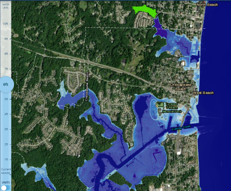
Explore updated mapping to include the recently released Interactive Maryland Coastal Atlas Map please click here. Adjust the Mean Height High Water (MHHW) level to see the impacts of flooding in your area.
Report flooding: Inform decision making at the Federal, State, County and Town level by reporting your images of flooding in the Town of Chesapeake Beach through the MyCoast App! It is easy and free to register, sign up today by clicking here. Simply upload your images to the MyCoast APP, MyCoast captures background data to automatically includes the weather conditions with your image allowing this information to be logged to understand impacts in the area. When the Town seeks funding for priority projects these images are used to understand the impacts of funding requests.

###